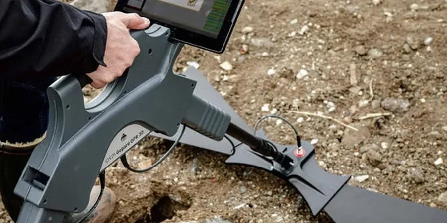
The alluvial fans and terrace deposits beneath Pasadena California create a complex subsurface environment. Clay-rich layers from ancient debris flows can mask buried utilities and voids. A GPR (Ground Penetrating Radar) survey cuts through that uncertainty without a single shovel break. We use 200 MHz to 900 MHz antennas to map stratigraphy and locate rebar, conduits, and abandoned foundations. This non-destructive method is ideal for the tight urban lots common in this city. Before we mobilize, we cross-reference known utility records and adjust antenna frequency based on expected soil conductivity. For deeper targets or areas with high clay content, we often combine GPR with a masw-vs30 survey to correlate radar reflections with shear-wave velocity profiles. The result is a clean, actionable map of what lies below grade.
We map rebar, conduits, and voids without breaking concrete. GPR cuts risk and saves rework on every Pasadena project.
Service characteristics in Pasadena California
Critical ground factors in Pasadena California
IBC 2021 and ASCE 7-22 mandate that all new construction in seismic zones identify subsurface anomalies that could affect foundation performance. Pasadena sits within the Raymond fault zone, where undocumented fill and abandoned utilities are common. A missed void beneath a slab-on-grade can lead to differential settlement and structural cracking during the next seismic event. We run GPR (Ground Penetrating Radar) survey lines on a 2-ft grid to capture every anomaly. Any target deeper than 5 ft gets flagged for follow-up drilling or test pits. This protocol aligns with ASTM D6432-19 and the city's grading ordinance. Skipping this step means accepting unknown risk under every footing.
Our services
We offer two targeted GPR survey packages for Pasadena California projects.
Utility & Rebar Mapping
Locate conduits, pipes, rebar, and post-tension cables before coring or trenching. We mark targets on the surface and deliver georeferenced CAD files. Typical accuracy is ±0.1 ft. Includes a written report with depth estimates and confidence ratings.
Void & Anomaly Detection
Identify subsurface voids, sinkholes, and undocumented fill beneath slabs, pavements, and retaining walls. We use 200 MHz antennas for deep voids and 900 MHz for shallow cavities. Deliverable includes depth-slice maps and interpreted cross-sections.
Common questions
What is a GPR (Ground Penetrating Radar) survey and how does it work?
A GPR survey uses radar pulses to image the subsurface. The antenna transmits electromagnetic waves into the ground. Reflections occur at boundaries between materials with different dielectric properties. We record the two-way travel time of each reflection. This produces a continuous profile of buried objects, soil layers, and voids. The method is non-destructive and requires no excavation.
How deep can GPR penetrate in typical Pasadena soils?
Penetration depth depends on soil conductivity. In the dry alluvial sands common in Pasadena California, we typically reach 8–12 ft with a 200 MHz antenna. In areas with high clay content near the Raymond fault, penetration may drop to 3–5 ft. We always perform a test scan on site to confirm achievable depth before starting the full survey.
How much does a GPR survey cost for a typical residential lot in Pasadena?
A standard GPR survey for a 5,000 sq ft residential lot in Pasadena California ranges between US$835 and US$1,120. This includes utility mapping on a 2-ft grid, real-time GPS tagging, and a CAD deliverable. Larger commercial sites or projects requiring 3D volume rendering will be quoted based on scope and access conditions.
Do I need a GPR survey if I already have utility plans?
Yes. As-built utility plans in Pasadena California are often inaccurate. Old records may not show abandoned lines, undocumented repairs, or private utilities installed after construction. A GPR survey validates existing plans and reveals hidden conflicts. This prevents costly utility strikes and project delays. We recommend a GPR survey before any slab coring or trenching.