Under ASCE 7-16, seismic site classification in Pasadena California requires measured shear-wave velocity profiles to 30 m depth. We perform seismic tomography surveys that map P-wave and S-wave velocity contrasts across the site, identifying bedrock geometry and potential fault zones. This method is the standard for projects near the Sierra Madre fault system, where variable alluvial and colluvial deposits overlie crystalline basement. The technique integrates refraction tomography for shallow velocity structure and reflection imaging for deeper stratigraphy, giving a 2D or 3D velocity model. Before finalizing foundation design, we often recommend combining this with a microzonificación sísmica study to evaluate local amplification effects, especially in areas with abrupt soil thickness changes.
Identifying a buried paleochannel beneath a Pasadena site avoided a 2.5 m differential settlement — seismic tomography revealed the hazard before foundation design.
Service characteristics in Pasadena California
Critical ground factors in Pasadena California
A common mistake we see in Pasadena is relying solely on borings for seismic site classification. Borings miss lateral variability — a single SPT log at one corner may indicate Site Class C while the opposite corner is Class D, separated by a buried stream channel. Without seismic tomography, the design spectrum is underspecified, leading to either over-conservative (wasteful) or unconservative (dangerous) foundation costs. We have documented cases where ignoring this lateral change resulted in differential settlement exceeding 2 inches during the 1994 Northridge aftershocks. The solution is a 2D velocity section across the building footprint before finalizing the geotechnical report.
Our services
We offer four complementary seismic tomography services tailored to Pasadena's geologic conditions:
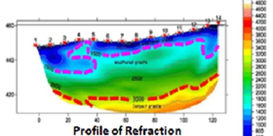
Refraction Tomography (2D)
P-wave first-arrival tomography for shallow velocity structure. Ideal for bedrock depth mapping and rippability assessment in the alluvial fans of the San Gabriel Valley.
Reflection Imaging (2D/3D)
CMP-stacked reflection sections for fault mapping and deep stratigraphy, particularly near the Raymond and Sierra Madre fault zones. Resolves dipping layers and buried channels.
MASW with Tomography Joint Inversion
Multichannel analysis of surface waves combined with refraction tomography for shear-wave velocity profiles (Vs30). Direct input for IBC Site Class and NEHRP design spectra.
Downhole Seismic (P-S Logging)
Borehole seismic velocity profiling to complement surface tomography. Provides direct P- and S-wave velocity measurements for modulus calculation and liquefaction triggering analysis.
Common questions
How does seismic tomography differ from standard SPT borings for site classification?
SPT borings give point measurements of blow counts and soil type at discrete depths, but they miss lateral variability. Seismic tomography produces a continuous 2D velocity section across the entire site, revealing lateral changes in stiffness, buried channels, or fault zones that a single boring would miss. For ASCE 7 site class, Vs30 from tomography combined with one or two confirmatory borings is the most reliable approach.
What is the typical cost range for a seismic tomography survey in Pasadena?
For a standard urban lot (approx. 100 x 50 m), a refraction/reflection survey with 48 geophones and interpretation typically ranges between US$2,960 and US$4,780. Larger sites or those requiring 3D imaging or MASW joint inversion can exceed this range. The exact quote depends on line length, source type, and whether borehole logging is required.
How deep can seismic tomography image in Pasadena's geology?
Refraction tomography typically resolves the top 15–30 m in alluvium and 30–50 m in bedrock. Reflection imaging can reach 80–120 m in favorable conditions (thick sedimentary units, low attenuation). In the Pasadena area, where alluvial fans overlie crystalline basement at depths of 20–60 m, the refraction component is usually sufficient for site class. The reflection component is added when fault mapping or deep stratigraphy is needed.